How to Speed up Drone Navigation System Development
The Challenge: the call for drone autonomy
Drones have become increasingly significant across multiple industries, from agriculture to delivery services. One critical aspect of drone operations is their ability to fly autonomously, using AI for optical navigation, yet it demands vast data for training and testing to ensure that the AI system can adapt to diverse real-life scenarios.
To overcome these obstacles, we have embraced a simulator environment for both data collection and system training in various scenarios. This approach eliminates the need for flight permissions and offers full control over weather and lighting conditions, leading to quicker and more cost-effective development.
However, this method has also brought about new challenges that demand further research and adjustments. In this article, we will delve deeper into these emerging obstacles and examine potential solutions.
And that’s how we did it
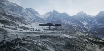
For our task, we experimented with various simulators and ultimately chose AirSim. This open-source, cross-platform simulator not only provides a highly realistic representation of drone behavior in both physical and visual aspects but also offers crucial APIs for data retrieval and UAV control.
AirSim boasts a broad range of pre-existing drone models, faithfully replicating their equipped cameras, depth sensors, GPS modules, and other hardware configurations, enabling us to gather diverse and authentic imagery to train our algorithm effectively.
Another significant advantage of this tool is the extensive customization options available for the environment. By carefully fine-tuning weather and lighting conditions, we can recreate a wide array of natural scenarios within a finite timeframe, which would be otherwise unattainable in real-world settings. Moreover, this approach eliminates the need for physical travel, expensive data collection, and most potential risks associated with real-world testing.

A Quick Guide to Drone Navigation
Data: the cornerstone of success
Amassing extensive data plays a huge role in the development of drone autonomy. Using a simulation for this purpose offers some fundamental advantages:
- It’s cost-effective compared to relying solely on physical drones. The expenses associated with building, maintaining, repairing, and replacing physical hardware can be significantly reduced or eliminated with simulators.
- Simulations offer a controlled and safe environment to explore different scenarios without the risk of equipment damage or harm, making them highly beneficial for training. Users can practice flying drones and gain valuable experience without risks.
- Physical drones face limitations regarding flight time, weather conditions, or restricted airspace. Simulations offer the flexibility to fly in diverse environments, weather conditions, and scenarios that might otherwise be inaccessible or unfeasible in the real world. It widens the scope of experimentation and expands the possibilities for data collection.
- Drone simulations allow for thorough testing of various scenarios, facilitating the evaluation and improvement of drone performance. Simulating responses to different weather conditions, obstacles, or complex flight paths can be challenging or risky to replicate in the physical world. Simulations provide a controlled setting to conduct such tests.
- Simulations gather extensive and precise flight parameters, including altitude, speed, acceleration, and control inputs, enabling more comprehensive research and development. This data is invaluable for analysis, performance evaluation, and enhancing drone designs and flight algorithms.
Artificial Intelligence: Training for Excellence
Drone navigation relies on visual data to perceive and navigate the surroundings effectively. By training AI models to recognize objects, landmarks, and environmental features, drones can navigate safely and avoid collisions. Training enables the creation of detailed maps, accurate real-time localization, and intelligent decision-making for efficient path planning and drone navigation during missions.
Model training also facilitates adaptation to changing conditions. By exposing the model to diverse lighting conditions, weather variations, and different terrains during training, the AI learns to generalize and perform robustly in unpredictable scenarios.
Finally, continuous algorithm training is a crucial task for improving and optimizing the optical navigation module. As the AI collects more data and receives feedback from real-world operations, the system should be regularly retrained to enhance performance, improve object recognition, and incorporate new features. This iterative training process ensures that the drone’s optical navigation continually evolves, maintaining high efficiency and effectiveness in various environments.
Test flights: fine-tuning drone performance
Drone flight simulator environments provide a virtual setting for training, evaluating, and fine-tuning drone performance, allowing for comprehensive testing and analysis.
The environment accurately models the physics and dynamics of the drone, including flight controls, propulsion systems, and aerodynamics, to ensure that the drone’s behavior closely resembles that of a physical drone, providing a realistic flight experience.
In the simulator, we can test different flight behaviors, such as takeoffs, landings, and aerial maneuvers under various conditions, to improve the system in a safe and controlled environment. We also can assess how the drone handles obstacles, wind gusts, and other challenging factors, identifying areas for further optimization.
AirSim provides extensive flight data, such as altitude, speed, trajectory, and sensor readings, that let us assess the drone’s performance, identify patterns or anomalies, and make data-driven decisions for enhancing flight algorithms and optimizing drone operations.
New challenges
The gap between virtual and real-world data
The limitations and lack of control over physical conditions make the real world a suboptimal data source. In contrast, a virtual environment provides greater flexibility to manipulate and execute numerous scenarios, including modifying weather and lighting conditions, experimenting with different terrain types, and introducing unexpected obstacles that need to be avoided.
While AirSim may not perfectly replicate the real world, there are strategies to address this challenge. Data augmentation techniques can be employed, incorporating satellite imagery and utilizing transfer learning to align simulator data with real-world geographic information. This involves comparing simulated sensor readings with accurate ground truth data derived from satellite imagery.
We can achieve more precise and robust training and testing by creating a virtual environment closely resembling real-world geography. Integrating satellite imagery into the simulation with further transfer of acquired knowledge back to the physical world results in significant cost and time savings, facilitating the development of AI optical navigation.
Other issues and how to deal with them
- Sensor Fidelity. Discrepancies between simulated and real-world sensors can be addressed by adjusting sensor parameters in the simulator to closely match real-world characteristics. Additionally, you can try sensor calibration to align virtual outputs with physical sensor data.
- Environment Differences. A simulator environment can be customized to closely resemble natural conditions: lighting, wind, and other dynamic elements. Data augmentation techniques will help introduce variability and simulate real-world scenarios, and integration of real-world data, such as satellite imagery or point cloud maps, into the simulator will add accuracy
- Motion and Dynamics. Fine-tune the drone dynamics model in the simulator using real-world flight data to improve alignment with real-world drones’ flight dynamics and control responses. Employ advanced control algorithms that adapt to the differences between simulated and real-world dynamics. Leverage machine learning techniques to learn the mapping between the simulator and real-world drone behaviors.
- Data Collection. Overcome challenges related to obtaining real-world drone data by collecting limited real-world data and augmenting it with simulated data to create a more diverse dataset. Utilize transfer learning techniques to leverage pre-trained models on similar tasks or domains to overcome limitations in real-world data availability.
Conclusion
Using a simulator proves to be a practical solution in developing and testing AI-based optical navigation systems. Simulators offer a controlled and repeatable environment, eliminating the costs and logistical challenges associated with real drone flights.
Simulators excel at creating highly realistic 3D models of the drone’s surroundings, enabling the AI system to undergo training and navigation exercises in a virtual world that closely mirrors reality. Through simulations, an array of scenarios can be generated, encompassing diverse weather conditions, lighting variations, and obstacles to empower the AI system to learn and adapt to various situations.
However, it is crucial to accept that simulators may not perfectly replicate the real-world environment, and there may be disparities between the data collected in a simulator and that obtained from a physical drone.
Drop us a line if you want to leverage the possibilities of simulators for drone navigation systems.